Humanity is waiting for another end of the world. Foreboding of the catastrophe, promised in 2012, is corroborated with the facts of a steadily increasing number of natural and anthropogenic disasters and accidents all over the world beginning from 2000. Death of many people is evidence of inability to predict time and place of a coming disaster. Only just fears disappeared concerning the most terrible event carried away an infinite number of persons: December 26, 2004 a tidal wave, caused with the most powerful earthquake for the last 40 years with a magnitude of 9.0 on the Richter scale, like a ten-meter wall came down upon the coasts of Sri Lanka, India, Indonesia, Thailand, Malaysia, Somalia and Kenya. The earthquake source occurred at a depth of thirty kilometers not far from the province Aceh in the northwest of the island Sumatra. About 300 thousands of people became victims of that tsunami. And again mass media shouts about tragic news – events in Japan, begun this year in March and still continuing. Unfortunately cataclysms grow into serious anthropogenic disasters. The question exciting everyone is – where will be the epicenter of the next tragedy and how to forestall events? Every year social conflicts increase depending on growth of a number of cataclysms. Scientists from all over the world are discussing numerous theories and forecasts of coming processes on earth and in the Universe. Everyone is busy to search for ways and development of programs to prevent economic damage and innumerable human casualties.
It is amazing, that there is something general in all these events, some unique factor, which has been ignored until now.
Take notice of the world statistics. In the XX century we can recollect some seismic catastrophes, which are assumed to be the greatest cataclysms: August 15, 1950 – earthquake in the Himalayas, December 4, 1957 – the Gobi-Altai earthquake and May 29, 1960 – earthquake in Chile.
The Himalayan earthquake in 1950 occurred in the high-mountain area in Tibet (near 35° north), close to the Indo-Chinese border. It was counted, that the energy of that earthquake approximately corresponded to the explosive energy of 100 thousands of nuclear bombs. Relief changes nearby the epicenter were enormous. There were avalanches and landslips in a great number in mountains. The total weight of shifted rocks was about two billion tons. Clouds of dust were lifted up. Cars were thrown off at 800 meters, a part of the railroad bed of 30 meters long was down approximately to 5 meters, and a highway area was completely destroyed.
The Gobi-Altai earthquake of 11-12 points on December 4, 1957 in the south of Mongolia (near 40° north). Earthquakes of such intensity were observed only under the bottom of an ocean, the character of their appearance on land was not studied. A strong force of the earthquake, shallow depth of center, practically absence of vegetation reduced to the fact, that traces on the surface, caused with the earthquake, were more fully-variable, than of any famous earthquakes. In the twinkling of an eye South Mongolia turned into a natural laboratory, where the most different geological processes were reproduced, usually inaccessible to see for research people. The earthquake began at noon from the powerful, but nondestructive warning earth tremor. Inhabitants had time to leave their houses, and when the next severe stroke crashed, and somewhere blew off buildings, nobody was inside. About a minute ago a thump was heard from the mountain chain and ground trembled. Then a thunder like explosions of colossal force was resounded. Huge, dark clouds of dust were lifted up above massifs, at first hid the highest mountains. Dust spread rapidly, covered the whole mountain range along 230 kilometers. Visibility in some areas did not exceed 100 meters. Air cleared only in two days. The major blow went after a thunder, almost destroyed all constructions. Appreciable fluctuation of ground was observed in the territory of 5 billion km2.
The earthquake in Chile on May 29, 1960 completely destroyed Concepcion (in the area of 35° south), existed more than 400 years. Valdivia, Puerto Montt and others tumbled into ruins. Earthquake shocks, avalanches in mountains and landslides occupied the area more than 200 thousand km2, that exceeded the territory of Great Britain. The coastal strip of an area of 10 thousand km2 dropped after the earthquake below ocean level and was found to be overlapped by a two-meter water sheet. One of the exceptional peculiarities of that catastrophic earthquake was descent of the vast coastal strip under the ocean level. It is hard to imagine the sizes of this tremendous geological phenomenon, precisely fixed with collation of topographic maps before and after the catastrophe. In a few seconds a land strip of 20-30 km wide and 500 km long dropped approximately at 2 m.
Of course, we should mention the events at the beginning of the XXI century, the current catastrophe broke out near the Japan coasts also in the area of the 35th latitude in northern hemisphere.
In the XX century the most popular model for explanation of the character of origin and forecast of future earthquakes was the model of "seismic belts”, see Fig. 1.
Within this model, the basic cause of an earthquake is shift of rocks by a fracture. The more “revival” break is, the more a force of an earthquake shock will be. Maximal breaks are connected with the biggest folded belts – Pacific and Mediterranean ones. The most of active volcanoes are referred to the high-seismic Pacific zone. In often cases epicentres of the powerful earthquakes are situated under the bottom of an ocean. Another high-seismic zone (Mediterranean belt) crosses Eurasian continent in the sub-latitude direction. It springs from the coasts of the Atlantic ocean (Portugal, Spain), covers the Mediterranean and South Europe, continues through high-mountain areas of Central Asia up to the Pacific ocean. In that belt there were the Lisbon earthquake in 1755 and the earthquake in Greece in 1870 (near 35° north). Strong earthquakes within seismic belts are one of manifestations of their high geological activity over hundred million years.
The model of origin of seismic activity, described above, is the most popular but not exceptional. It is also difficult to answer about origin itself and topography of big tectonic breaks. In the present article we suggest another version about origin of earthquakes, natural disasters and other cataclysms.
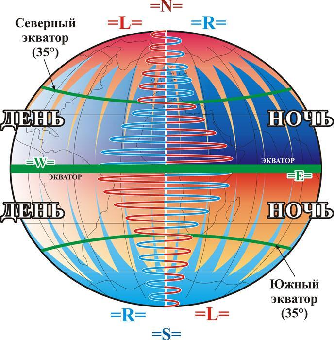
At the end of the XX century a Russian scientist and researcher V.A. Nekrasov has discovered in the Earth’s biosphere a special energy geometric structure, called by him “Earth’s Form Field”, in which the leftism-rightism energy and such phenomenon as dissymmetry are revealed. Interacting with all living and non-living things energy processes in biosphere, connected with its dissymmetry, are subject to the appointed law of rhythmics. He writes in his monograph about diurnal rhythms of changes of the leftism-rightism energy in the Earth’s Form Field:
- The leftism energy is more in the Earth’s biosphere in the daytime in the northern hemisphere above the 35th parallel (nearer to North Pole), and there is more rightism in the nighttime. The nearer to equator, the more amplitude the process of the dissymmetric fluctuation has;
- The rightism energy is more in the Earth’s Form Field in the daytime in the northern hemisphere below the 35th parallel (nearer to equator), and there is more leftism in the nighttime. The nearer to equator, the more amplitude the dissymmetric fluctuation has.
In Southern hemisphere a rhythmical picture is opposite, i.e. the process of change of biospheric dissymmetry in northern and southern hemispheres occurs in antiphase.
During the long-term research V.A. Nekrasov discovered, that periods of activity of every system in biosphere fluctuate according to the rhythms of change of biospheric dissymmetry and manifest themselves in all aspects: seismic activity, natural disasters, high mental activity, anomalous changes of weather conditions and etc.
Equator should be considered as a peculiar space on the Earth, where sharp change of intensity of manifestations of the rightism-leftism energy occurs during a day. There are two particular transitions in the structure of the Earth’s Form Field – the 35th parallel in both hemispheres of Earth (northern and southern), called by V.A. Nekrasov as Northern equator and Southern equator (Fig. 2). These latitudes are bounds, where diurnal change of the leftism-rightism energy in biosphere occurs, so areas of northern and southern equators should be considered as extreme. The observations of many years indicate, that exactly in these areas of Earth overwhelming majority of cataclysms have happened.
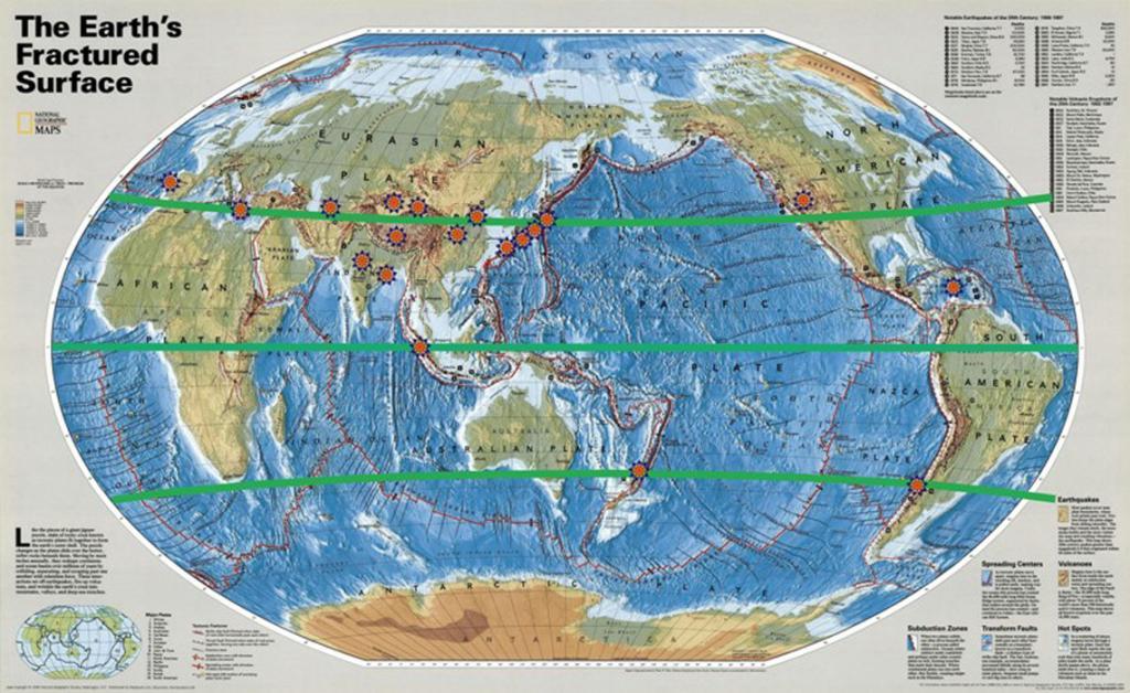
Take note of brief statistics of large-scale earthquakes for the last five centuries (see map, Fig. 3). The table is drown up according to the data of information center of the United States Geological Survey:
| № |
Year of earthquake |
Country |
Topography |
| 1 |
1556 |
Shaanxi, Xian, China |
near 35° north |
| 2 |
1693 |
Noto, Sicily |
near 35° north |
| 3 |
1700 |
Cascade, North America |
near 40° north |
| 4 |
1737 |
Calcutta, India |
near 22° north |
| 5 |
1755 |
Lisbon, Portugal |
near 38° north |
| 6 |
1870 |
Greece, southern districts. |
near 35° north |
| 7 |
1897 |
Assam, India |
near 24° north |
| 8 |
1923 |
Kanto, Tokyo, Yokohama, Japan |
near 35° north |
| 9 |
1948 |
Ashkhabad, Turkmenistan |
near 38° north |
| 10 |
1950 |
Tibet, indo-chinese border |
near 35° north |
| 11 |
1957 |
Gobi, Altai, southern Mongolia |
near 40° north |
| 12 |
1960 |
Concepcion, Chile |
near 35° south |
| 13 |
1976 |
Tien Shan, northeastern China |
near 38° north |
| 14 |
2004 |
Sumatra Island |
near 0° equator |
| 15 |
2008 |
Chengdu, Sichuan, China |
near 35° north |
| 16 |
2010 |
Haiti |
near 15° north |
| 17 |
2010 |
New Zealand, southern districts |
near 35° south |
| 18 |
2011 |
Japan |
near 35° north |
Besides earthquakes other natural disasters daily occur on the Earth: volcanic eruptions, tornados, avalanching, hurricanes, floods. All of these processes are subject to a strict cyclicity and always connected with fluctuations of biospheric dissymmetry in the Earth’s Form Field.
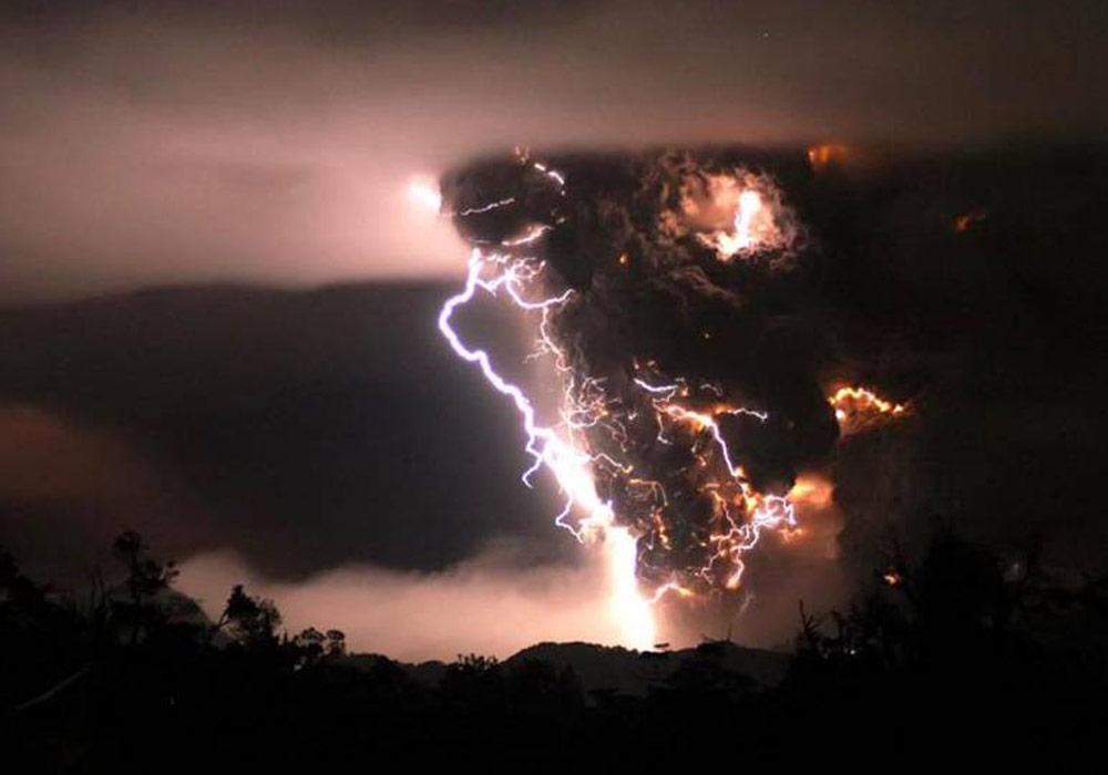
Figure 4 demonstrates Chait?n volcano eruption during a storm in the middle of the night on May 3, 2008 in Chaiten, Chile. The Chaiten volcano, situated to the south of Chile’s capital Santiago (35° south), was considered as extinct, because had not been active for some hundred years.
The basic sources of disasters on planet are connected to the appointed place in biosphere, and in ancient times humanity tried to settle beyond such a location. Therewith enormous earthquakes happen in the areas, where there are no settlements. But the peculiarity of these 35th parallels is not only high risk of calamities. Active dynamics, observed on these “equators”, connected with the diurnal rhythm of change of biospheric dissymmetry, effects on some social features, e.g.: origin of ancient civilizations, namely Mesopotamia, countries of the Mediterranean coast, centres of cultural conception in Tibet, China, India and etc. It is possible, that such behaviour of dissymmetry in biosphere in the present areas of the Earth, sharp diurnal transitions, influencing on people, favour their high mental activity, not allowing them to be in equilibrium. A “belt of war conflicts” should be also taken into account, especially today an overwhelming number of such conflicts will be observed between the 30th and 40th parallels.
The northern equator still keeps many secrets, and different versions and myths are evidence of this fact, e.g.: the secret of Bermuda triangle (the Bermuda Islands are exactly in the area of the 35th parallel), Atlantis fall. Some versions exist, that another “Atlantis” is revealed near the 35th parallel in the Pacific ocean, near the coasts of Japan.
It is important to remember, that forecast of disasters depends on the level of our knowledge about the Earth, laws, connecting processes of cosmic nature with any processes in biosphere. Using of knowledge about the Earth’s Form Field and about fine-field rhythms in planning of economical activity can help to organize safe and harmonious life of humanity on the planet.